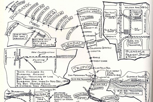
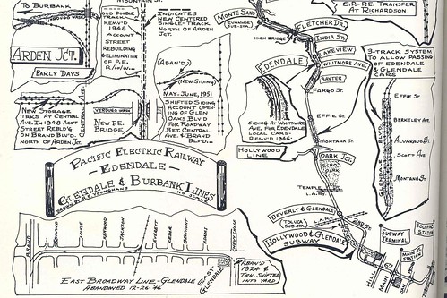
| MY FASCINATION WITH DEFUNCT Los Angeles transportation systems continues, with this gem of a map from the Metro Transportation Library and Archive Collection. Click the top or bottom half of this Burbank-Glendale Line map to see amazing detail of Pacific Electric Railroad conveniences gone by. In fact look along the top border of the bottom half for a handwritten note, "high bridge," referring to the long-gone Fletcher Drive trestle. And hey, there's the lost city of Tropico again!
|
4 comments:
So cool. Do you have a date for those maps?
I'm guessing early 50's, which just doesn't seem that long ago.
My grandmother grew up in Roscoe--now called Sun Valley -- and often talked about taking the streetcars to Temple St. downtown where her family could get kosher chickens and then in the summer taking the streetcars to summer at the beach in a cottege in Santa Monica.
Looks like this map reflects the system between 1951 and 1953, just before Pacific Electric Railway was sold. And the dismantling began.
This was the second most used line in the Pacific Electric system, after the Watts/Long Beach main line.
Trains started at the Subway Terminal Building, and went through the 1 mile subway. Only this and the Hollywood lines used the subway, going from 1925-1955.
Then trains went up Glendale Blvd, across the lip of the hills, then into Atwater. That's why Glendale Blvd. is so wide there.
From there, they stopped in Glendale or continued on to Burbank.
Don't know when this map was made, but was drawn by PE Historian Roy Younghans. Probably after the fact, that is, after 1955 when the lines were ripped out.
Post a Comment