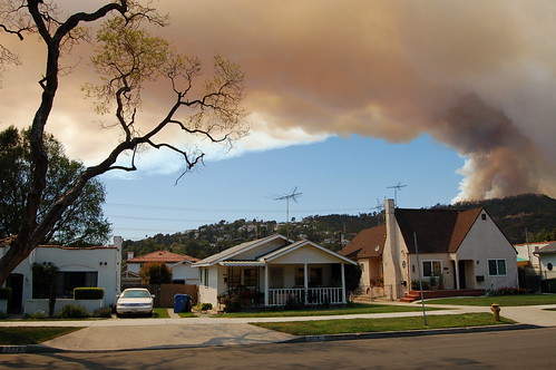
IT LOOMS ORANGE over us, the fire burning right now on the other side of Griffith Park. Sirens all over. Copters in the air. I am feverishly uploading photos to this new Flickr set. Stay tuned.UPDATE 2:45PM - Seven photos loaded
3:05PM - National news: "Fire threatens Hollywood sign"
3:10PM - Local TV: fire contained to north side of Hollywood Hills, away from sign; take THAT, red states
3:20PM - Cats sleeping through whole thing!
3:29PM - Thumbnails added below
3:33PM - CBS2: 150 acres burning, cause under investigation, origin behind Oakwood Apartments on Barham; 39 companies responding, six helicopters
3:43PM - Caren: new shots from 17th floor, Renaissance Hollywood
3:48PM - Great shots from other side of hills, hereinvannuys
3:52PM - And from roof of Capitol Records
4:04PM - CBS2: fire could be contained by sundown
6:30PM - Dramatic new photos (and some of mine) at nowpublic.com
|
|


9 comments:
Pretty crazy, huh? I was just on Sunset in Silver Lake and it at least **looks** like the Hollywood sign's about to be engulfed in smoke. I think it's just the way the smoke's pouring over the hill though. The sky over my apartment at Vermont/Los Feliz is full of brownish/orange smoke.
Great photo. It looked just like this from my house in Eagle Rock too.
Good work, AVN. I was working a few miles south of the fire--I posted some images here. I took the liberty of linking to your post...
+++
Like everybody else in town, I was able to get a shot too. Its on my blog.
Yeah others captured good photos too but I really like how AVN framed the fire looming over the quaint homes of the sleepy neighborhood and got the almost mushroom cloud effect that the fire had when it first started. The photo has an almost apocalyptic feel to it.
I agree. When I first saw the smoke from Bev Hills/WeHo, I was stunned. I thought it was the armageddon...or at least terror level yellow or something.
great pictures! i was so tempted to turn around on my walk to grab my camera.
Forget the cameras -- can anyone post a MAP showing where the fire seems to be and the neighborhoods being evacauated? (Or a link to someplace where this exists?) From the descriptions on the news it seems that everything east and south of the observatory, through Los Feliz Blvd., including Commonwealth Avenue, especially around Dundee are in danger and have been ordered to evacuate as of 8 pm. Several highways are now closed. It doesn't seem that the news sites or blogs are able to keep up, but I don't need to see more pictures of smoke, I need to know who needs help evacuating and what neighborhoods are in danger!
Sorry, this is a bit of an amateur news-gathering organization here. For better coverage, try the LA Times breaking news blog.
Post a Comment